


(Pocket-lint) – Space is an incredible place, not just for the breathtaking views from new angles, but no doubt for the sheer feeling of insignificance the visions of our universe must give for astronauts lucky enough to blast off up and out of the atmosphere.
The International Space Station is in regular orbit around the Earth. Not only serving as a home to astronauts and cosmonauts but also functioning as a unique science laboratory.
Circling the Earth at roughly 250 miles up, travelling at 17,500 mph and orbiting the planet every 90 minutes, the space stations bares witness to some pretty incredible views. We’ve gathered some of the most impressive for you to see.
An aurora timelapse
There are no images quite as impressive as shots of the Aurora Borealis taken from space. This one was taken by European Space Agency astronaut Thomas Pesquet while aboard the International Space Station.
More impressive though is the timelapse video he took of the lights.
SpaceX Crew Dragon Endeavour
This image from the ISS shows the arrival of SpaceX Crew Dragon Endeavour. This craft was carrying Commander Shane Kimbrough and pilot Megan McArthur, along with astronauts Akihiko Hoshide and Thomas Pesquet who then boarded the ISS to join the crew of Expedition 65 on 24 April 2021.
Sun selfie
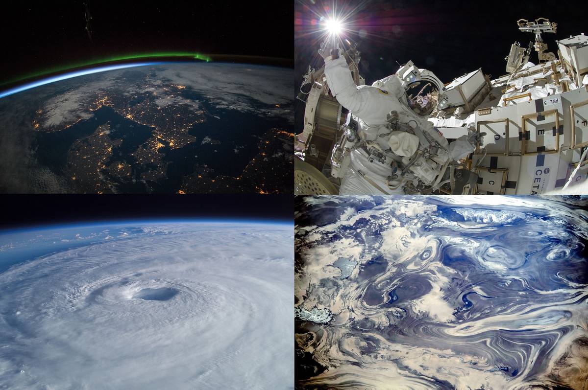
A close-up of the action shows one of the engineers on the space station carrying out repairs on the station during a spacewalk. This image was captured in 2017 and shows a brilliant view with the sun glaring in the distance.
“Expedition 32 flight engineer Suni Williams appears to touch the bright Sun during the mission’s third spacewalk. During the six-hour, 28-minute spacewalk, Williams and Japan Aerospace Exploration Agency astronaut Aki Hoshide (visible in the reflections of Williams’ helmet visor), flight engineer, completed the installation of a Main Bus Switching Unit (MBSU) that was hampered last week by a possible misalignment and damaged threads where a bolt must be placed. “
London at Night
A nighttime flyover of London shows the lights of the city shining brightly and the twists and turns of the River Thames cutting through the middle.
Sierra Nevada de Santa Marta, northern Colombia
Mountain ranges make for a regularly popular image of our world as captured by those orbiting above. Somehow these giant landmasses appear insignificant when seen from this view and yet they are some of the tallest and most impressive sights our Earth has to offer.
This photo of Sierra Nevada de Santa Marta was taken from 215 miles above:
“This early morning image, taken by astronauts looking from the International Space Station, shows a dramatic view of the many peaks of Colombia’s Santa Marta massif.
The highest of these (approximately 5700 m, 18,700 feet), named for Christopher Columbus, is so high that it supports a small but permanent snow cap (image far left), even though it lies only ten degrees north of the Equator.
The summits are so high that trees cannot grow–landscapes appear grey because only grass and small shrubs can survive the cold. Interestingly, glacial erosion features can be seen throughout the grey summit zone area–showing that an ice cap hundreds of times larger than the snow cap existed during the geologically recent ice ages.
Most of the image shows the lower slopes covered with the green tinge of forests. A forest fire gives off smoke in a large valley.
The Santa Marta snow cap is the only place where snow can be seen from the tropical beaches of the Caribbean coast, 45 km distant (outside the top of the image). The region is a tourist attraction because visitors experience changes in climate, landscapes, vegetation and wildlife as they ascend the mountains. The massif contains dozens of endemic species. Much of the massif is now protected as a national park, now designated as a Biosphere Reserve by UNESCO in 1979. A 2013 report identifies the reserve as the most irreplaceable park in the world for threatened species.”
Scandinavia at night
Space is an incredible place, not just for the breathtaking views from new angles, but no doubt for the sheer feeling of insignificance the visions of our universe must give for astronauts lucky enough to blast off up and out of the atmosphere.
The International Space Station is in regular orbit around the Earth. Not only serving as a home to astronauts and cosmonauts but also functioning as a unique science laboratory.
Circling the Earth at roughly 250 miles up, travelling at 17,500 mph and orbiting the planet every 90 minutes, the space station bears witness to some pretty incredible views. We’ve gathered some of the most impressive for you to see.
ISS repairs
Of course, orbiting the planet, the International Space Station needs regular repairs and these are parts of the duties of the crew. The highlights of their work include some pretty magnificent views:
“Backdropped by a colorful Earth, including land mass that covers parts of New Zealand, astronaut Robert L. Curbeam Jr. (left) and European Space Agency (ESA) astronaut Christer Fuglesang, both STS-116 mission specialists, participate in the mission’s first of three planned sessions of extravehicular activity (EVA) as construction resumes on the International Space Station.”
The Nile at night
Another incredible view from the space station captured by NASA astronaut Scott Kelly (@StationCDRKelly) shows the view of the River Nile at nighttime.
The streetlights and lights from the cities and towns below look almost like fires burning on the Earth’s surface.
The deserts of Iran
The views of the deserts of Iran from space show some fascinating patterns in the surface below. Almost fluid-like, these sights are actually rock formations and the results of erosion too:
“As the International Space Station passed over the deserts of central Iran, including Kavir, one of the Expedition 38 crew members used a digital camera equipped with a 200mm lens to record this image featuring an unusual pattern of numerous parallel lines and sweeping curves.
The lack of soil and vegetation allows the geological structure of the rocks to appear quite clearly. According to geologists, the patterns result from the gentle folding of numerous, thin, light and dark layers of rock. Later erosion by wind and water, say the scientists, cut a flat surface across the folds, not only exposing hundreds of layers but also showing the shapes of the folds.
The dark water of a lake (image centre) occupies a depression in a more easily eroded, S-shaped layer of rock. The irregular light-toned patch just left of the lake is a sand sheet thin enough to allow the underlying rock layers to be detected. A small river snakes across the bottom of the image. In this desert landscape, there are no fields or roads to give a sense of scale. In fact, the image width represents a distance of 65 kilometres.”
The moon 16 times a day
The International Space Station takes some adjusting too. The orbit around the Earth happens with such frequency that the astronauts get an intriguing view – including seeing the moon rise 16 times a day.
“On Sunday, July 31, 2011, when Expedition 28 astronaut Ron Garan aboard the International Space Station looked out his window, this is what he saw: the moon. And, he saw it 16 times. Said Garan, “We had simultaneous sunsets and moonsets.” For Garan and the rest of the station crew, this extraordinary event is a daily occurrence. Since the station orbits the Earth every 90 minutes, each day the crew experiences this about 16 times a day.”
Rivers and snow in the Himalayas
The Himalayan range of mountains makes for some incredible views wherever you are fortunate enough to see them. From the International Space Station, the sight looks even more intriguing. The veins on the surface show where the rivers and waters have cut through the landscape.
The photo from 2015 shows a fantastic image of the snow-encrusted mountain ranges below:
“This oblique image was taken from the International Space Station as astronauts flew over the Himalaya range in China near the Indian border. The view shows one of the main ranges of the Himalaya Mountains across the bottom of the image, where peaks cast strong evening shadows against the snow. The peaks reach great altitudes (5200 m, 17,000 feet), with those just outside the lower margin reaching high enough (6500 m, 21,325 feet) to host glaciers.
Rivers have eroded rock from these high mountains and deposited the sediment as broad alluvial fan surfaces (across the middle of the image). The snow cover shows these strikingly smooth surfaces. A trellis-work of gullies cuts into these surfaces casting sinuous shadows. The largest river in the view has cut a 500 m-deep (1650 foot) canyon through the fans (image left).
Although the rivers in the view drain northward from the Himalayas, they ultimately flow back south through the mountain ranges as the Sutlej River (outside the image)–in one of the largest canyons in the world–before entering the lowlands of Pakistan and finally reaching the Arabian Sea.”
Hawaii from above
Another snap captured from the station, this time by European Space Agency astronaut Samantha Cristoforetti (@AstroSamantha) shows the island of Hawaii. A close look at this photo shows the peaks of the volcanoes too.
The eye of the storm
In 2003, Astronaut Ed Lu captured this broad view of Hurricane Isabel from the International Space Station. This image nicely shows the eye of the storm and the majesty of nature.
The eye of Hurricane Isabel
Snapped in September 2003, this image shows a view over the Atlantic Ocean and the eye of Hurricane Isabel as it passed over that area.
These views of cloud formations and harsh weather conditions look a lot less threatening from above. Certainly a beautiful view of the wonder of mother nature.
A view from a visor
NASA astronaut Ricky Arnold (@astro_ricky) took this selfie during the May 16, 2018, spacewalk to perform upgrades on the International Space Station.
He shared the incredible image on his Twitter account for everyone to see. Certainly an interesting view.
Mt Cleveland
This photo, taken in 2006, shows an aerial view of Mt Cleveland as it erupts – an ash cloud bursting forth into the atmosphere. A thoroughly impressive view of nature at its most dangerous:
“Eruption of Cleveland Volcano, Aleutian Islands, Alaska is featured in this image photographed by an Expedition 13 crewmember on the International Space Station.
This most recent eruption was first reported to the Alaska Volcano Observatory by astronaut Jeffrey N. Williams, NASA space station science officer and flight engineer, at 3:00 p.m. Alaska Daylight Time (23:00 GMT).
This image, acquired shortly after the beginning of the eruption, captures the ash plume moving west-southwest from the summit vent. The eruption was short-lived; the plume had completely detached from the volcano summit two hours later. Ash plumes from Cleveland Volcano have reached heights of 12 kilometres and can present a hazard to trans-Pacific jet flights.
The fog bank visible at image top centre is a common feature of the Aleutian volcanoes. Cleveland Volcano, situated on the western half of Chuginadak Island, is one of the most active of the volcanoes in the Aleutian Island chain extending west-southwest from the Alaska mainland. At a summit elevation of 1,730 meters, this stratovolcano is the highest in the Islands of the Four Mountains group. Carlisle Island to the north-northwest, another stratovolcano, is also part of this group. Magma that feeds eruptions of ash and lava flows from the volcano is generated by subduction of the northwestward-moving Pacific Plate beneath the North American Plate. As one tectonic plate subducts beneath another, melting of materials above and within the subducting plate produce magma that can eventually move to the surface and erupt through a vent (such as a volcano). Cleveland Volcano claimed the only known eruption-related fatality in the Aleutian Islands during 1944.”
Momotombo volcano, Lake Managua
In late 2018, an astronaut aboard the International Space Station snapped this photo of Momotombo Volcano in Western Nicaragua. Hard to believe this area was once referred to as “the smoking terror”.
From this angle, you can see the full magnificence of the volcano and its sulfur-stained peak. Regular plumes of vapour can be seen coming from this volcano and it has erupted as recently as 2015.
Cape Cod, Massachusetts
An aerial view of Cape Cod like you’re unlikely to see elsewhere. This barrier island is thought to be one of the youngest of its kind – likely formed 20,000 years ago by glaciers.
“Astronauts aboard the International Space Station used a very long lens to shoot this detailed image of the northern tip of Cape Cod–showing 8.5 miles (14 km) of its 65-mile (105 km) length. Cape Cod is one of the biggest barrier islands in the world, and it protects towns like Provincetown and its port facilities (image centre) from storm waves coming in from the Atlantic Ocean. It thus also protects much of the Massachusetts coastline. The cream-coloured features are symmetrically shaped dunes built mainly by northwesterly winter winds (image upper centre) blowing beach sands inland.”
Midsummer sunrise, Gulf of Saint Lawrence
Another brilliant snap shows a perfectly timed sunglint image. The sun’s reflection over the Canadian provinces of Newfoundland and Labrador were photographed at around 4 am by an astronaut aboard the space station. For people on the ground, the sun wouldn’t rise for almost another hour – just another highlight of the different experiences for the crews of the station versus us lowly folk down below.
Adele Island, Northwest Australia
“Astronauts aboard the International Space Station took this detailed image of a tiny island with many concentric zones around it.
Adele Island, off Australia’s north coast, is only 2.9 km (2 mi) long, but the entire tidal zone with all the concentric zones is 24.5 km (15.2 mi) long, surrounded by extensive sandbanks in the tidally exposed area…
Shallow water surrounding the island is light blue, compared with the deeper open ocean (upper left, lower right). During times of low sea level (repeatedly during the glacial stages of the past 1.7 million years), the entire platform and surrounding zones would have been dry ground–so that astronauts would have seen a much larger island occupying all of the image...”
Special Purpose Dextrous Manipulator
Although perhaps not the most breath-taking of images on this list, this photo is nonetheless a powerful view of the work carried out on the station. In May 2019 work was carried out in this section of the ISS to repair damaged components. This sort of essential work ensures the station can continue to function fully.
NASA explains “The International Space Station continues to be a critical test bed where NASA is pioneering new methods to explore space, from complex robotic work to refuelling spacecraft in flight and developing new robotic systems to assist astronauts on the frontier of space. Technologies like these will be vital as NASA looks to return astronauts to the Moon by 2024.”
Moonrise over the aurora
Back in 2016, astronaut Kate Rubins shared this image of a moonrise from the International Space Station. A brilliantly beautiful shot shows the majestic atmospheric glow of the aurora below. A backdrop of billions of stars is truly humbling from this angle.
The Frozen Wild Dnieper River
Another incredible view of a frozen tundra captured by a European Space Agency astronaut aboard ISS.
“Curling snow drifts are magnified by the terrain around the 1,400 mile Dnieper River, flowing from Russia to the Black Sea.
European Space Agency astronaut Thomas Pesquet, a member of the Expedition 50 crew, captured this image from the International Space Station on “Feb. 9th, 2017, saying, “winter landscapes are also magical from the International Space Station: this river north of Kiev reminds me of a Hokusai painting.”
Each day, the International Space Station completes 16 orbits of our home planet as the crew conducts important science and research. Their work will not only benefit life here on Earth, but will help us venture deeper into space than ever before. Crew members on the space station photograph the Earth from their unique perspective, hovering 200 miles above us, documenting Earth from space. This record is crucial to how we see the planet changing over time, from human-caused changes like urban growth, to natural dynamic events such as hurricanes, and volcanic eruptions.”
Laguna Colorada, Bolivia
This incredible image of Laguna Colorada shows a view of the lake below. The colours of the waters can be seen changing over time thanks to the algae that make up part of the ecosystem.
“Astronauts aboard the International Space Station took this detailed image of the brightly coloured Laguna Colorada, unique in this part of the Bolivian Andes Mountains and a well-known feature to astronauts.
The lack of atmospheric haze at great altitude–the lake lies at 4300 m above sea level (14,100 feet)–helps make images of the region especially clear. The strong red-brown colour of this shallow, 10 km-long lake is derived from algae that thrive in its salty water. But the lake occasionally has green phases because different algae display different colours, the type being determined by the changing salinity and temperature of the water. As the lake water evaporates in the desert climate it becomes saline. Snow-capped volcanoes appear image top centre and lower left. Ancient shorelines show that the lake has been larger in the past.
Laguna Colorada is the centre of a wildlife reserve (listed in 1990 as a “Ramsar Wetland of International Importance”) and home to large numbers of flamingo. Access roads on three sides of the lake are used by tourists who visit these other-worldly landscapes. “
The snow-capped Kiska Volcano on Kiska Island
It’s not just awesome views of space and the edges of our world that are visible from ISS. The station also gives fantastic visions of areas of our home planet that would be otherwise tricky to visit, nevermind see from this angle.
This view from May 2019 shows a snow-covered Kiska Island, part of the Aleutian Islands in the Alaska Maritime National Wildlife Refuge.
Buenos Aires, River Plate, Argentina
A muddy view of Buenos Aires from 220 miles up. This one might not be as colourful or as pretty as some of the other shots of our planet from above but that doesn’t mean it’s not impressive.
“This image was taken as astronauts aboard the International Space Station flew over the eye-catching delta and green swamps of the Parana River (image right) on the Atlantic coast of Argentina. The Parana River, South America’s second largest after the Amazon River, pours brown muddy water into a wide estuary known as the River Plate (image centre and left). The grey mass of Argentina’s capital city, Buenos Aires (metro population 12.74 million in 2010), is less prominent seen from space (upper left), although astronauts quickly attune their eyes to the subtle signature of such cityscapes. Numerous small farm plots on red soils surround the delta and city.
The muddy river sediment ultimately derives from erosion of the rocks of the Andes Mountains far upstream–mirroring the colour of the Amazon River which is also turbid and also rises in the Andes Mountains. In this image tidal backwash transports the muddy water a short distance upstream into the smaller Uruguay River (image lower right).”

Best mirrorless cameras 2022: Top interchangeable lens cameras from Sony, Canon, Panasonic and more
By
·
What are the best mirrorless cameras? 1. Sony A1 · 2. Panasonic Lumix GH6 · 3. Sony A7 IV · 4. Olympus PEN E-P7 · 5. Fujifilm X-E4
Salt Ponds, coastal flats, Western Australia
Images of coastlines are common among the back catalogue of photos snapped from the International Space Station.
These photos also represent a common view for astronauts looking down on our planet as they are the best indicators of which part of the world they’re looking down at. The familiar lines of the coasts are easy to identify compared with other landmasses.
Venice Lagoon
Another incredible view of our planet snapped from space in 2014.
This photo shows the narrow barrier island which protects the Lagoon of Venice from the strong waves of the northern Adriatic Sea.
The colours of the waters below are the result of many boats and other watercraft passing over the surface. Wear and tear on the surrounding lands caused by the wake of these boats has been of concern. So much so that a study was set-up to monitor the health of the Lagoon.
Great Barrier Reef Near Whitsunday Islands
The Great Barrier Reef is an impressive sight from any angle. Though most people see it from tourist photographs, astronauts see it from 200 miles up – with the entire reef visible.
This photo shows just 10 miles of the 1,700-mile reef. The reefs are easily visible from the station thanks to the change in colour – the iridescent blues of shallow lagoons contrast with the dark blues of deeper surrounding waters.
Red Sprites Above the US and Central America
This snap from the space station captures a view over Mexico when a red sprite can be seen over the white light of an active thunderstorm.
These sprites are not caused by lightning in the usual sense, but are major electrical discharges, a cold plasma phenomenon similar to the discharge of a fluorescent tube. Large thunderstorms sometimes result in a burst of sprite energy but they are rarely captured on film.
Caribbean Sea Viewed From the International Space Station
A panorama photo of the Caribbean Sea that includes parts of Cuba, the Bahamas and Florida.
This brilliant image captures the glow of the atmosphere ringing our home planet too.
Flooding on the Mekong River floodplain, Thailand and Laos
The Mekong River sits on the border between Thailand and Laos. This photo from the space station taken in 2015 shows evidence of flooding in the area. The floods below were caused by heavy monsoon rainfall that fell around July that year and affected everyone in the area.
The crew of the International Space Station have often been tasked with documenting these sorts of floods. This sort of imagery helps authorities to assist with relief efforts on the ground and to save lives.
The port of Sfax, Tunisia
This image shows Sfax, Tunisia as it appears from the International Space Station and highlights the radiating street pattern of Tunisia’s second city.
These streets radiate out from the ancient walled city and create a distinct and beautiful image from above. The tiny buildings below, merely specks from this distance, house a population of over 900,000.
Fish farms basins, NE China
Astronauts snapped this high-contrast image of the grid patterned fish farms on the coast of China. The view includes fish-farm basins built out of wood and shallow seabeds, mudflats and bays. Water flows from ships can be seen on the surface below too.
Stargazing
Another incredible view from above, best described by NASA:
“Knowing the exact time and the location of the ISS, scientists were able to match the star field in the photo to charts describing which stars should have been visible at that moment. They identified the pattern of stars in the photo as our Milky Way galaxy (looking toward its centre). The dark patches are dense dust clouds in an inner spiral arm of our galaxy; such clouds can block our view of stars toward the centre.
The curvature of the Earth crosses the centre of the image and is illuminated by a variety of airglow layers in orange, green, and red. Setting stars are visible even through the dense orange-green airglow.
The brightest light in the image is a lightning flash that illuminated a large mass of clouds. The flash reflected off the shiny solar arrays of the ISS and back to the camera. The dim equatorial cloud sheet is so extensive that it covers most of the sea surface in this view.
Knowing the exact time and the location of the ISS, scientists were able to match the star field in the photo to charts describing which stars should have been visible at that moment. They identified the pattern of stars in the photo as our Milky Way galaxy (looking toward its centre). The dark patches are dense dust clouds in an inner spiral arm of our galaxy; such clouds can block our view of stars toward the centre.
The curvature of the Earth crosses the centre of the image and is illuminated by a variety of airglow layers in orange, green, and red. Setting stars are visible even through the dense orange-green airglow.
The brightest light in the image is a lightning flash that illuminated a large mass of clouds. The flash reflected off the shiny solar arrays of the ISS and back to the camera. The dim equatorial cloud sheet is so extensive that it covers most of the sea surface in this view.”
Sunset over the Med
An incredible view of a sunset over the Mediterranean with the Alps, Adriatic sea and Italy just about visible below. The sun reflects across the surface of the planet, showing the beauty of our home from above.
An Astronaut’s View from Space
NASA astronaut Reid Wiseman captured this beautiful view of the Earth with a sunrise over the ocean. A brilliant reflection of the beauty of our world.
Iberian Peninsula at Night
An early evening photo of the entire Iberian Peninsula (that includes both Spain and Portugal) taken from the International Space Station in 2014. The bright glow of the towns and cities below can be easily seen, even from 200 miles up.
Flying Through an Aurora
European Space Agency astronaut Alexander Gerst took this photo in 2014 as the space station passed through an aurora. These impressive views are caused by small energy particles from the sun interacting with the magnetic field lines in the Earth’s atmosphere. These interactions cause a reaction with the atmosphere as the oxygen sets off a beautiful green and red light display in the sky.
Earth’s changing vistas
This image was taken in 2015 and shows the views seen by NASA astronaut Terry Virts, Commander of Expedition 43, astronaut Samantha Cristoforetti and Russian cosmonaut Mikhail Kornienko at that time. These views are clearly visible from special windows on the space station that allow a 360-degree observation of our world below.
Hurricane Gonzalo
Another photo of a hurricane that makes these dangerous natural occurrences look like harmless swirls of cloud from above. This image, from 2014 shows Hurricane Gonzalo over the Atlantic Ocean.
Morning Aurora From the Space Station
This photo from 2015, was taken by NASA astronaut Scott Kelly (@StationCDRKelly) and shows the magnificent view of the green lights of the aurora as seen from the space station.
Panorama of the Night Sky and the Milky Way
Impressive visions from the space station not only show amazing views of Earth but also the stars and constellations around us. This eye-catching panorama of the night sky and the Milky Way was captured by NASA astronaut Reid Wiseman in 2014. The majesty of the stars dominating the skies above our planet. Below, the sands of the Sahara desert make the Earth glow with an orange hue.
A colourful long-exposure
Taken in July 2020, this photo shows a long-exposure snap from ISS showing a colourful glow from the Earth’s atmosphere.
Sun Glint in Angola
The sun catches the light of the river below as the space station passes over the African continent. This incredible view makes the water look almost gold.

Russian resupply above the night’s sky
Here a Russian supply ship is seen docked with the ISS while below the lights of Europe can be seen on the surface with millions of people going about their business as the station orbits above.
The Canadarm2 robotic arm
A fairly magnificent view of the marvellous tech used aboard the International Space Station.
“The Cygnus space freighter from Northrop Grumman, with its prominent cymbal-shaped UltraFlex solar arrays, is pictured moments after its release from the Canadarm2 robotic arm ending its 83-day stay at the International Space Station.”
Clouds above the Philippine Sea
The views from the International Space Station sure are staggering. This snap shows long whisps of clouds above the surface of the Philippine Sea.
San Francisco Bay
An interesting view of San Francisco from above shows the striking size of the bridges that connect it to Oakland and the Golden Gate Bridge too. The large patch of greenery that forms Golden Gate Park also looks impressive from this height.
The night lights of Tokyo
Another incredible night-time view, this time from Tokyo. The street lights almost look like the arteries of the city – the flowing lifeblood of a busy economy.
Everest
NASA Astronaut and Flight Engineer for the ISS Mark T. Vande Hei took this impressive top-down view of Mount Everest from onboard the space station.
He challenged viewers on Twitter to see if they could spot the mountain in the range spanning the ground below.
Curved Earth
This view has it all. During a space walk, this photo was taken and shows not only the wonderful curve of our home planet but also the wonderful blues of the Caribbean sea below.
Writing by Adrian Willings.


